Transit and urban planning enthusiasts have been using this winter’s dramatic snow to hunt sneckdowns–snowy paved areas which highlight road surface that is not being used by the car traffic it was intended for. The idea has expanded from local and specialist blogs like DNAChicago and This Old City, which helped to kick off the trend, to more general media (Gizmodo, Atlantic and the Economist) and become a growing twitter hashtag. But since local news today is more about water than snow let’s take it one step further!
Sneckdowns can demonstrate MORE than potential increased pedestrian areas. We could be calling out decreased hardscape generally –identifying areas used by neither foot traffic nor cars which could be targeted for green space or permeable surfaces.
Replacing hard surface with permeable paving can be expensive but may also require less frequent replacement and can certainly reduce storm water runoff and the associated costs for sewer infrastructure. The City of Chicago already lists it as a Best Management Practice for handling storm water. Likewise, pedestrian refugia and curb extensions cost money to install but pay off in safer streets and reduced traffic accidents.

What is a Neckdown?
Also known as a sidewalk extension or bump out, neckdowns are areas where the curb is pushed out past the parking lane into the street. This naturally prevents parking in intersection, slows vehicular traffic, and provides pedestrians with a safe place to stand and check for cars before crossing rather than having to crane around the parking lane. The City of Chicago includes these in their repertoire of traffic calming devices but calls them “bump outs” or curb extensions on their Tools For Safe Streets Guide.
And … What is a Sneckdown?
A Sneckdown is a Snowy Neckdown – a term claimed by Aaron Naparstek of MIT’s Urban Studies and Planning Department, who was looking for a twitter hashtag to follow the phenomenon. To explore the idea for ourselves we gathered snapshots from a transect in Lakeview (specifically, one person’s walk to work) and then highlighted them for improvement potential.
Come take a walk with us ...
Intersecting One-Way Neighborhood Streets:

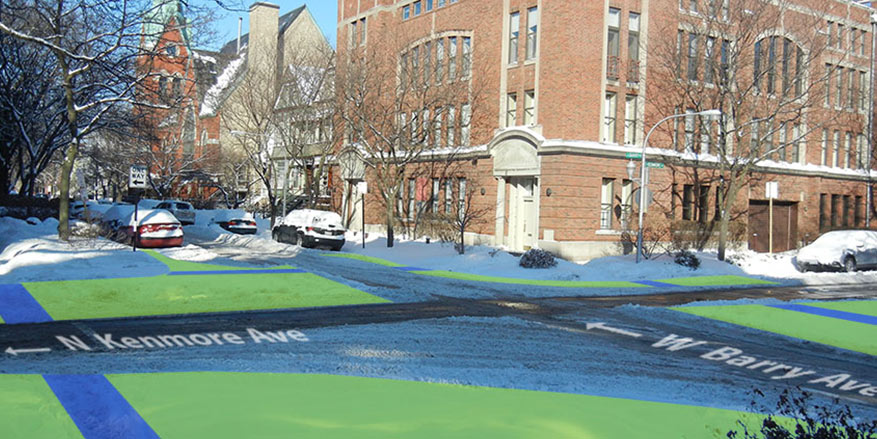
Barry and Kenmore: Quiet neighborhood streets have big potential for improvement in the too-much-hard-surface department. The waste of asphalt pavement is especially clear here at the intersection of two one-way streets with parking on both sides. While there are tire tracks crossing straight through the intersection and curving through turns (right from Kenmore on to Barry or left from Barry onto Kenmore) but there are big (several hundred square feet) areas of parking lane at the other two corners of the intersection which are never driven over.
The permeable and pedestrian areas of this interchange could be drastically improved by reclaiming the width of the parking lanes and the two non-turnable corners. This change would also help prevent confused drivers from turning the wrong direction onto one way streets.
Six Way Diagonal Street Intersection:

Lincoln, Barry, and Greenview: Chicago’s lakeside grid of streets is interrupted by numerous diagonal streets which feed in from outlying areas toward downtown. These angled streets create a series of odd six way intersections with major and minor grid streets that can be a trial for pedestrians and drivers alike but are particularly interesting to a sneckdown hunter.
The paved surface could be reduced by turning the parking lane areas into permeable surface and there’s a clear potential pedestrian refuge in the foreground between the through traffic area and the right turn passage.
Six Way Diagonal Street Intersection:
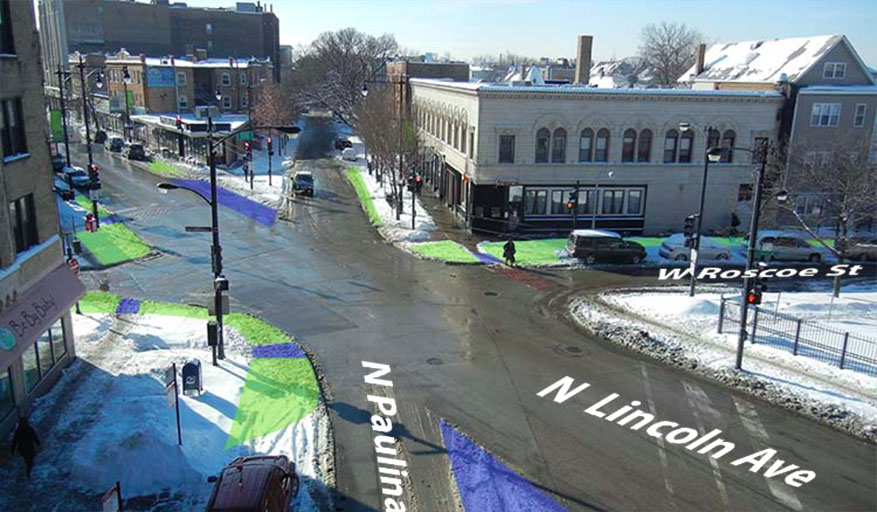
Lincoln, Paulina, and Roscoe: Following Lincoln north west yields a plethora of these complex interchanges. One of the most tangled is the Lincoln/Belmont/Ashland intersection, which moss has proposed replacing with a traffic circle for improvements to both pedestrian safety AND a reduction in its huge area of paved surface. The Lincoln/Paulina/Roscoe intersection shown above is best visualized from the nearby Paulina Brown Line station. It already has added paved pedestrian areas to the shard-like corners between Lincoln and Paulina, with right turn lanes cutting behind.
These could be improved by extending pedestrian area into the parking lane (top left) and by reclaiming the parking lane of Paulina for permeable surface (lower left).
Neighborhood Intersection:

Byron and Ravenswood: Just outside our own office is a great example of the unnecessary width of paved streets. Parking lanes and driving lanes are hogging area that could be better used for grass, permeable pavers or rain gardens.
Along the upper right of the photo it’s clear that Ravenswood could be reduced in breadth and, in the foreground, there’s a wide curving area (parking lane in the middle of the block) that no cars are driving on which could clearly be reclaimed for permeable or planted surface. NB: this morning that area is currently an enormous lake of ice water which could be prevented with better drainage.
So there you have it. As you enjoy stomping through puddles this afternoon, keep your eyes peeled for areas of paving which are going unused. A few more winters like this might spark an urban planning revolution.
Is there a great sneckdown near you? Tell us all about it in the comments below!